As enterprises continue to evolve in their digital transformation journey, there is a need for augmenting Azure Maps content with project-specific and private business knowledge of places. Today we’re launching Azure Maps Creator in preview to extend location intelligence to indoor spaces.
Enterprises are taking advantage of Azure Maps capabilities to optimize business operations and transform their business strategy using location and map services. With IoT-powered systems delivering new and more accurate data than ever before, defining new patterns for taking advantage of location data findings is essential. Creator includes a new set of capabilities that allow an enterprise to securely create and use indoor maps that dynamically change as new events in spaces occur. The data is not used to improve Azure Maps, customers own and are in full control of the created map content, including defining how to secure access using Azure Maps authentication and authorization options. You can develop solutions for the general public or for selected authenticated users for virtually any indoor space such as offices, stores, factories, and hospitals for facility management, occupant and guest experiences, productivity tools, and more.
Azure Maps provides SDKs to easily build web and mobile applications with location and map services. Creator is fully integrated with existing Azure Maps capabilities. Using the same skill sets and developer tools, solutions can combine indoor maps and analytics with outdoor Azure Maps services for roads, traffic, mobility, weather, and more.
Create indoor maps
You can take advantage of existing data for creating and maintaining indoor maps. During construction or remodeling phases, architecture and engineering work includes floorplan drawings created with computer-aided drawing (CAD) tools. Creator offers a conversion service that enables developers to upload these CAD-based floorplans and convert them into map data which can be further enriched with other details. For example, you can create logical spaces representing areas covered by cameras or with Wi-Fi signal, and add equipment locations to help find printers and fire extinguishers. You can create maps with multiple buildings, like corporate campuses and hospitals, put the buildings in relation to each other using the geographic context, and easily add useful functions such as routing from one building to another.

We envision an ecosystem of partners offering specialized services or complementary technology making it easier to gather and process useful indoor map data. One of the partners that is an early adopter of the Creator capability is Archidata. Archidata has 25 years of experience in developing tools and processes for upgrading architectural documents to allow its real estate clients to evolve at the same pace as technology easily and inexpensively. Archidata has developed the capability to convert customers’ architectural plans to meet Azure Maps Drawing package requirements from any document format, including AutoCAD drawings, PDF, scanned paper plans, or Revit models.
Indoor maps in action
Indoor maps can be used in a multitude of scenarios taking advantage of map visualization, IoT, and location analytics. The Azure Maps SDK is enriched with a dedicated Indoor module so that applications delivering indoor experiences can be easily extended with the numerous rich capabilities the SDK offers.
Indoor map visualization brings an intuitive way to make decisions. It can be used to locate stores and gates in airports, alerts in factory production lines, book meeting rooms, show space utilization trends, and conditions. Indoor map visualization is delivered by the Azure Maps Render service and utilizes optimized vector tilesets. Each space and element of the map comes with a style to more rapidly deliver compelling maps. If you need applications that reflect map styles defined by live data, for example, if you are making use of Azure Digital Twins to track temperature or people count for different areas provided by IoT devices, you can use the Feature State service to visualize the latest measurements and deliver dynamic map styling in your applications.
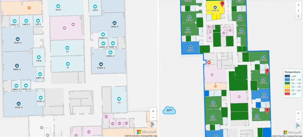
Using Web Feature Service (WFS), you can also use your indoor map data to perform spatial queries and find, for example, rooms and equipment based on a given area of interest or other criteria such as the place name. The information retrieved can be used to visualize places of interest on maps but also for analytics and integration with other systems. For example, you can access and use the spatial data of your indoor map in other functions such as the Azure Maps Geofence API. In addition to all great functional value the WFS provides, this service adheres to the Open Geospatial Consortium API standard for Features which makes your solution highly interoperable with other commercial and open sourced geospatial products.
With the ability to view indoor spaces, it’s natural to want to view objects on the map as they move around in real-time. The challenge has been that most devices are not location-aware inside a building, as GPS signals are obscured. To solve this, the next Windows release will feature a new Wi-Fi-based indoor location solution built into the geolocation API. When deployed, IT departments can use it to find lost laptops, or employees can get live navigation through a building indoor map. Azure Maps abstracts away from the method to let you choose the positioning technology suitable for your projects. While Windows is working together with enterprise Wi-Fi partners to build indoor positioning into the OS, you could also build cross-platform, mixed reality solutions with Azure Spatial Anchors accessible across HoloLens, iOS, and Android devices. Applications tracking indoor positions can take advantage of Azure Maps and bring additional insights to mixed reality applications (for example, room properties and devices in close proximity) as well as trigger automated processes built using Azure Maps Spatial service and others. Azure Maps also helps extend user experiences beyond indoor by making use of the same IoT events and underlying services to deliver spatial analytics.
SIRL (Sirl.io), an innovative indoor GPS and analytics platform, locates and communicates with mobile devices used by visitors and staff at accuracy down to 12 inches (30 cm) using precise indoor object mapping provided by Azure Maps Creator. SIRL is currently working with Fairway Market in the New York metropolitan area to add wayfinding and location-triggered recommendations to Fairway’s Mobile Checkout App. In addition, SIRL is helping Fairway’s category managers with merchandising insights and optimization via a cloud-based analytics dashboard.
Willow is a technology company that creates Digital Twins of real assets, either buildings or infrastructure. Willow’s Digital Twin combines siloed data sets, including geospatial data, asset data, maintenance data, and occupant data into a virtual replica of the built form, which is then overlaid with live information. This is an emerging technology field in the built world as the physical and digital realms merge. Willow will leverage Azure Maps to provide users with an accurate, floor map of their assets as well as leverage Azure Maps for their Geographic Information System.
“By integrating Azure Maps into Willow, we can provide contextual insights to owners and operators” said Dale Brett, Co-Founder and Chief Product Officer at Willow. “Azure Maps is helping us bring spatial context to IoT. That means we can drive more efficient maintenance practices, improve tenant safety and wayfinding, and provide asset owners with transparency across multiple sites.”
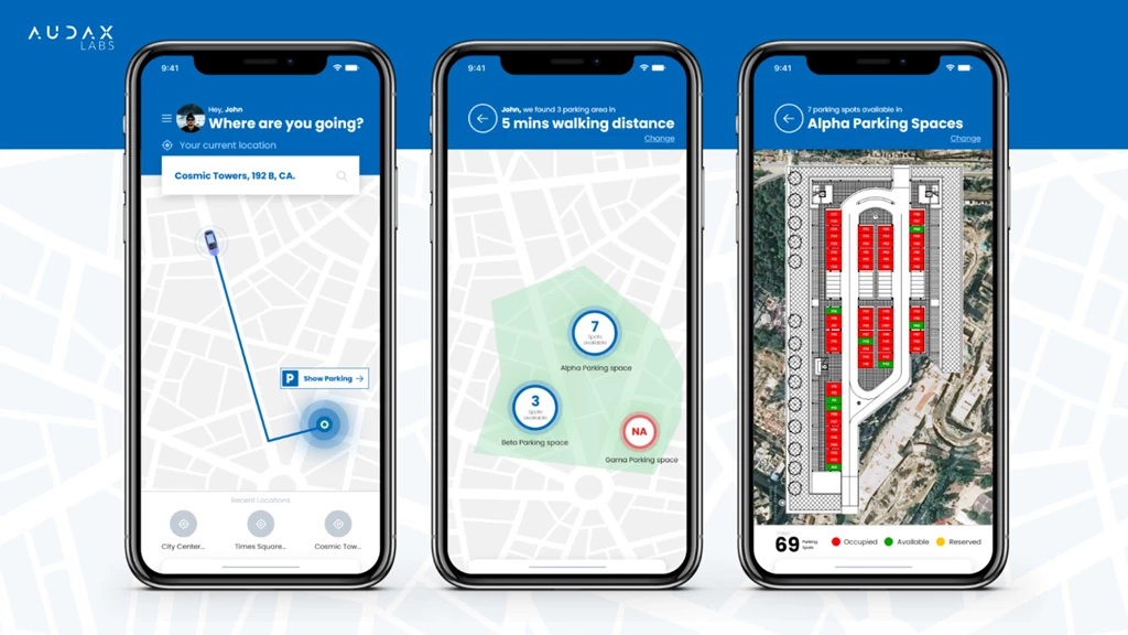
Audax Labs is currently working with the Azure Maps team to develop solutions for the Retail Industry around parking garages. They have built a prototype for streamlining the parking process using the Creator capability. Customers can find and reserve a spot in the parking lot for calculated for their estimated time of arrival.
Next steps
Start learning more and easily develop modern solutions with Azure Maps today.
- Learn more about Azure Maps Creator.
- Create your first indoor map.
- Creating Intelligent Spaces.