This blog post was co-authored by Chad Raynor, Principal Program Manager, Azure Maps.
New and recent updates for Microsoft Azure Maps include support for Azure Maps integration with Azure Active Directory (generally available), integration with the Microsoft Power Apps platform, Search and Routing services enhancements, new Weather services REST APIs (in preview), and expanded coverage for Mobility services.
Read on to learn more about the latest features and integrations for Azure Maps:
Azure Maps integration with Azure AD support now generally available
Azure Maps integration with Azure Active Directory (Azure AD) is now generally available allowing customers to rely on Azure Maps and Azure AD for enterprise level security. This update includes support for additional role-based control (RBAC) roles for fine grained access control. Azure Maps supports access to all principal types for Azure RBAC including; individual Azure AD users, groups, applications, Azure resources, and Azure Managed identities. Additionally, Azure Maps documentation now includes expanded implementation examples and estimates on implementation effort to assist choosing the right implementation method based on type of scenario.
Geospatial features in Power Apps powered by Azure Maps now in preview
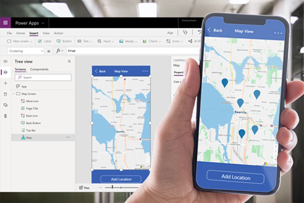
Microsoft Power Apps announced the preview of geospatial capabilities powered by Azure Maps. This includes both an interactive map component as well as an address suggestion component. Power Apps is a suite of apps, services, and connectors, along with a and data platform that provides a rapid app development environment to build custom apps for your business needs.
To get started with the new geospatial components, you don’t need to be a professional developer to take advantage of these features. You can add these components with the ease of drag-and-drop and low-code development. As an example, you can build an app for your field service workers to report any repair needs including the location of the work and detailed pictures.
The preview includes the following:
- Interactive vector tile maps supporting multiple base map styles including satellite imagery.
- Address search with dynamic address suggestions as you type and geocoding. The component suggests multiple potential address matches that the user can select and returns the address as structured data. This allows your app to extract information like city, street, municipality—and even latitude and longitude—in a format friendly to many locales and international address formats.

Figure 1. Azure Maps interactive vector tiles in Power Apps.
Search and Route services enhancements
Search business locations by brand name
Through Azure Maps, Search services customers have access to almost 100 million Point of Interest (POI) locations globally. To help our customers to restrict the POI search results to specific brands, we introduced brandSet parameter that is supported by all Search APIs covering POI search capabilities.
As an example, the users of your application want to search restaurants by typing ‘restaurant’ or selecting category ‘restaurant,’ and you want to show them all the restaurants that are under your brand umbrella. In your API request, you can pass us multiple brands or just one brand name, and results will be filtered based on those.
POI Category Tree API in preview
Azure Maps POI Search APIs support almost 600 categories and sub-categories. In an effort to make it easier for our customers to understand and leverage this information to optimize their queries, we have added POI Category Tree API to our Search services portfolio, and introduced categorySet parameter that is supported by all Search APIs covering POI search capabilities. Azure Maps POI category API provides a full list of supported POI categories and subcategories, along with an ID for each category.
Customers can use POI category API along with Search API to query for POIs mapped to a specific category ID. With these capabilities customers can increase the accuracy of POI search results when customers use category IDs instead of description strings.
Request reachable range by travel distance
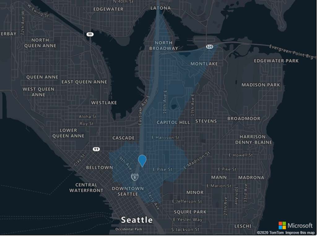
Azure Maps offers a full suite of vehicle routing capabilities, for example, to support fleet and logistics related scenarios. Azure Maps Get Route Range API, also known as Isochrone API, allows customers to determine the distance from a single point in which a user can reach based on time, fuel or energy. The API allows customers to also request reachable range based on travel distance returning the polygon boundary (isochrone). The returned isochrone, good for visualization, can also be used to filter for spatial queries, which opens a wide variety of applications for spatial filtering.
For example, when there is a traffic incident at a given point, you need to know which of the electronic traffic signs should be updated to alert drivers of the incident. To figure out which signs to update, you want to know which signs drivers would hit within 5 kilometers of driving to the incident. You can use Route Range API to calculate the reachable range and after that you can use the returned polygon to check which signs resided in that polygon. See our code sample to test route range features in action.

Figure 2. Map visualizing reachable range based on travel distance.
Search Electric Vehicle (EV) charging stations by connector type
Azure Maps Route services support today’s multiple routing related customer scenarios covering routing support for private, electric, and commercial vehicles like trucks. To make it possible for our customers to build advanced features for their Electric Vehicle (EV) applications, our customer can now restrict the result to Electric Vehicle Station supporting specific connector types to find the most suitable EV charging stations. Consider that you have an application that allows your users to determine if there are suitable charging stations along their planned routes, or as business fleet owner you want to know if there are enough specific types of charging stations for your employees to charge their vehicles while they are delivering goods for your customers. You can now accomplish this through all Azure Maps Search service APIs with POI search capability, like Search Fuzzy and Search Nearby APIs.
Mobility services updates
Expanded coverage
We are announcing that we expanded our Mobility service coverage globally covering today almost 3,200 cities, to offer the best in-class public transit data. To highlight some improvements, we now support countries and regions such as Liechtenstein and metro areas like Hyderabad (India), Côte d’Azur (France), Dakar (Senegal), Rio Verde (Brazil) and San Francisco-San Jose (CA, US). You can find all the supported metro areas from our full Mobility services coverage page. One metro area can be country/region, city, or a group of multiple cities.
MetroID is no longer a required parameter for multiple Mobility APIs—To make it easier for our customers to request transit data, we have changed request parameter metroID optional for the following Mobility services APIs:
- Get Nearby Transit
- Get Transit Stop Info
- Get Transit Route
- Get Real-time Arrivals
- Get Transit Line Info
As a result, Azure Maps customers don’t need to first request metroID parameter by calling Get Metro ID API to be able to call public transit route directions API.
Weather services updates
Severe Weather Alerts
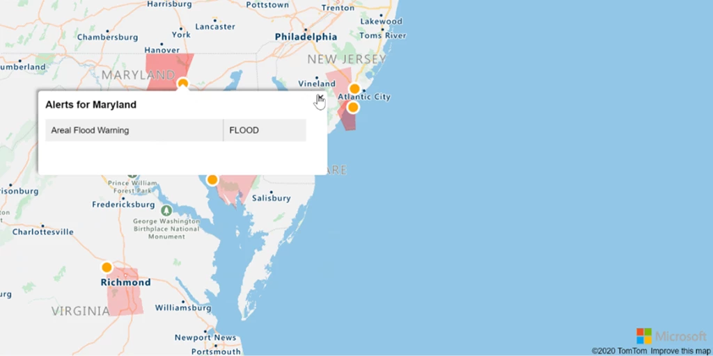
Severe weather phenomenon can significantly impact our everyday life and business operations. For example, severe weather conditions such as tropical storms, high winds, or flooding can close roads and force logistics companies to reroute their fleet—causing delays in reaching destinations and breaking the cold chain of refrigerated food products. Azure Maps Severe Weather Alerts API returns the severe weather alerts that are available worldwide from both official Government Meteorological Agencies and leading global to regional weather alert providers.
The service can return details such as alert type, category, level, and detailed descriptions about the active severe alerts for the requested location, such as hurricanes, thunderstorms, lightning, heat waves or forest fires. As an example, logistics managers can visualize severe weather conditions on a map along with business locations and planned routes, and further coordinate with drivers and local workers.

Figure 3. Active Severe Weather Alerts on a map.
Azure Maps Indices API
There may be times when you want to know if weather conditions are optimal for a specific activity, such as outdoor construction, indoor activities, running or farming, including soil moisture information. Azure Maps Indices API returns index values that will guide users to plan future activities. For example, a health mobile application can notify users that today is good weather for running or for other outdoors activities like playing golf, and retail stores can optimize their digital marketing campaigns based on predicted index values. The service returns in daily indices values for current and the next 5, 10, and 15 days.
Request past and future radar and satellite tiles
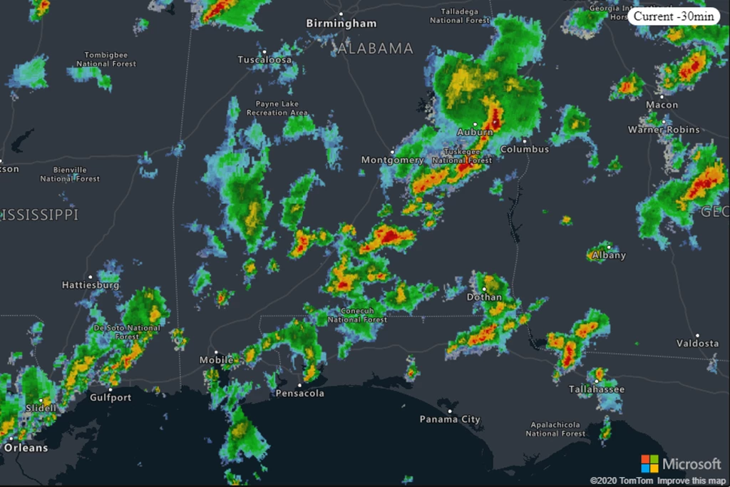
In addition to real-time radar and satellite tiles, Azure Maps customers can now request past and future tiles to enhance data visualizations with map overlays by calling directly Get Map Tile v2 API or requesting tiles via Azure Maps web and mobile SDKs. Radar tiles are provided up to 1.5 hours in the past and up to 2 hours in the future and are available in 5-minute intervals. Infrared tiles are provided up to 3 hours in the past in 10-minute intervals.

Figure 4. Historical radar tiles visualized on a map.
We want to hear from you
We are always working to grow and improve the Azure Maps platform and want to hear from you. We’re here to help and want to make sure you get the most out of the Azure Maps platform.
- Have a feature request? Add it or vote up the request on our feedback site.
- Having an issue getting your code to work? Have a topic you would like us to cover on the Azure blog? Ask us on the Azure Maps forums.
- Looking for code samples? There’s a plethora of them on our Azure Maps Code Sample site. Wrote a great one you want to share? Join us on GitHub.
- To learn more, read the Azure Maps documentation.
